Tropical depression accelerates dlightly while moving westward over Philippine Sea west of Guam. Image from DOST / Pagasa
MANILA, Philippines — The tropical depression outside the Philippine area of responsibility (PAR) is still not directly affecting the country, while easterlies are forecast to bring rains over parts of Luzon and Visayas, the state weather bureau said on Friday.
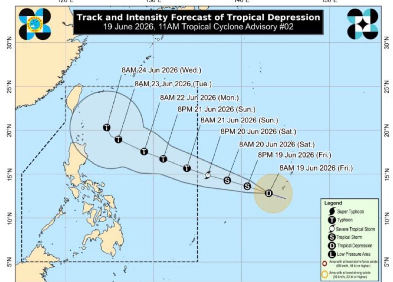
In the 5 p.m. forecast of the Philippine Atmospheric, Geophysical, and Astronomical Services Administration, weather specialist Loriedin De La Cruz – Galicia said that the tropical depression was last located 1,735 kilometers east of Eastern Visayas as of 3 p.m.
READ: Tropical depression outside PAR may become a strom late Friday
Article continues after this advertisement
The tropical depression maintained its strength as it was carrying a maximum wind speed of 55 kilometers per hour (kph) and gustiness of up to 70 kph. It slightly accelerated as it moved west-northwestward at 35 kph.
FEATURED STORIES
NEWSINFO
NEWSINFO
NEWSINFO
“It will not have a direct effect on our landmass. It is also currently not affecting the weather and sea conditions of our country,” de La Cruz – Galicia said.
“Once it enters the PAR, there is a high chance that it will enhance the southwest monsoon or habagat that will bring rains in a huge part of the country by Sunday and early this week,” de La Cruz – Galicia added.
She reiterated that the tropical depression may enter the PAR by Saturday evening or Sunday morning. Once it is inside the country, it will be named Francisco and is forecast to further intensify.
READ: Tropical depression east of Visayas may enter PAR by weekend
Article continues after this advertisement
Weather forecast for Saturday
Meanwhile, she said that Metro Manila and the rest of Luzon will experience partly cloudy to cloudy skies due to localized thunderstorms.
Article continues after this advertisement
She added that easterlies, or the warm winds coming from the Pacific Ocean, will bring cloudy skies with a high chance of rains in the next 24 hours over Visayas and Palawan.
She also said that no gale warning is raised in any seaboards of the country.
Temperature forecast in the following areas:
Your subscription could not be saved. Please try again.
Your subscription has been successful.
Laoag, Ilocos: 24°C to 33°C
Baguio: 18°C to 25°C
Metro Manila: 26°C to 34°C
Tagaytay: 24°C to 31°C
Tuguegarao: 26°C to 37°C
Legazpi: 26°C to 33°C
Kalayaan Islands: 26°C to 33°C
Puerto Princesa: 26°C to 33°C
Iloilo: 25°C to 33°C
Cebu: 27°C to 33°C
Tacloban: 27°C to 33°C
Cagayan de Oro: 25°C to 32°C
Davao: 25°C to 34°C
Zamboanga: 26°C to 33°C
/jpv
Read the full article at Philippine Daily Inquirer →📄Source document: Philippine Atmospheric, Geophysical, and Astronomical Services Administration (PAGASA)
2 reports
 Philippine Daily InquirerIndependentCenteryesterday
A tropical depression remains outside the Philippine Area of Responsibility (PAR), with no direct impact on the country. However, easterly winds are expected to bring rain to parts of Luzon and Visayas. The weather bureau reports the system has maximum sustained winds of 55 km/h and gusts up to 70 km/h, moving west-northwest at 35 km/h. Officials note that if the system enters PAR, it could intensify the southwest monsoon, leading to widespread rainfall.
Bias read (Center): The article provides factual information about weather patterns without taking a stance or using biased language. It quotes officials from the state weather bureau and presents meteorological data objectively.
Official sources cited
- government Philippine Atmospheric, Geophysical, and Astronomical Services Administration (PAGASA)
Philippine Daily InquirerIndependentCenter2 days ago Tropical depression outside PAR may become a storm late FridayThe Philippine Atmospheric, Geophysical, and Astronomical Services Administration (Pagasa) reported that a tropical depression located outside the Philippine area of responsibility (PAR) may intensify into a tropical storm by Friday afternoon or evening. The system is currently 1,850 kilometers east of Eastern Visayas, with maximum sustained winds of 55 km/h and gusts up to 70 km/h. Pagasa forecasts that the system could potentially reach typhoon status by Sunday as it moves westward over warm tropical waters. The tropical depression is expected to enter the PAR between Saturday evening and/or
Bias read (Center): The article provides a straightforward report on meteorological data without any apparent ideological framing, emphasis, or biased language. It focuses solely on the technical details provided by Pagasa, a government agency, and does not take a stance or interpret the information beyond what is fact
Official sources cited
- government Philippine Atmospheric, Geophysical, and Astronomical Services Administration (Pagasa)
 PH
PH